The work of the 3D Survey Group at Saqqara by Francesco Fassi and Alessandro Mandelli
Since 2010 the Milan team has been developing an informative system for the management of the Veneranda Fabbrica del Duomo di Milano, the main cathedral of Milan, based on the 3D survey of the whole monumental building. At the same time, members of the team have been involved in the 3D survey of the archaeological excavation of the underground station ‘Municipio’ in Naples, where photogrammetric survey techniques were thoroughly tested. The 3D Survey Group is also the main research group of the ERC-funded project LIFE (Living In a Fringe Environment), directed by Dr Corinna Rossi, focussing on the interdisciplinary study of the Late Roman settlement of Umm al-Dabadib, located in the Kharga Oasis (Egypt’s Western Desert). The team is now developing a new line of research and investigation focussing on creating an informative system specifically dedicated to archaeological excavations.
The Group’s main task at Saqqara is to survey the concession and the excavation. This may sound like a simple task, but it is done in an innovative and ground-breaking way – providing 3D metric and accurate representations nearly real-time during the excavation, and 2D orthorectified images immediately after the daily fieldwork. All this information is then uploaded into the new Saqqara information system; an extremely useful tool not only during the recording phase in the field but also, at a later stage, to re-elaborate the information, share it with specialists working on the pottery, human remains, wood or architecture in a collaborative environment, and disseminate it to the wider public.
During the first week of work, the existing fixed points to which the topographic survey is tied were double-checked using the expedition’s new total station. Then two separate activities started: the overall 3D survey of the already excavated tombs, and the detailed 3D survey of the area that is being excavated, using photogrammetry for all the different contexts identified.

Fig. 3. Survey of the tomb of Maya
The aim of the general survey of the already excavated tombs is also to fix the absolute and relative position of each monument, previously surveyed independently from one another. By the end of this third week, the Milan team completed the survey of the tombs of Maya (fig. 3), Tia and Tia, Horemheb, Pay and Ray, Meryneith (fig. 4) and Ptahemwia. The photogrammetry has been preliminarily elaborated by our laptops during these afternoons of work back in the dighouse and added to the general survey of the expedition’s excavation area.
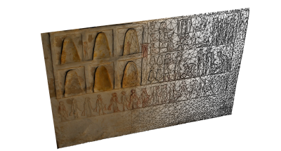
Fig. 4. Scene in the tomb of Meryneith
The photogrammetric survey of the excavated contexts is being carried out with a resolution of 0.5 mm, in order to fully grasp the composition of the various deposits and structures that are being exposed and removed during the fieldwork. Recording the contexts with a 3D georeferenced web-based informative system is a complex and innovative challenge and Francesco, Alessandro and Paolo have been spending long evenings discussing the best and most efficient way to structure the information that is being collected, with the support of the other members of the 3D Survey Group working from Milan. This part of our work is giving us the chance to carry out not only an interesting fieldwork, but also a challenging piece of research on the field together with our colleagues of the Museo Egizio. In this respect, the 3D Survey Group wishes to thank the co-directors of the mission, Dr Christian Greco and Dr Lara Weiss, for the invitation to join their fieldwork, and looks forward to continuing this interesting and fruitful collaboration.